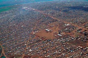
Lesson plans for ages 12-14 in Geography: Living Conditions in Refugee Camps in Africa
Lesson plans for ages 12-14 in Geography: Living Conditions in Refugee Camps in Africa
-

LESSON 1: Refugee camps as large as cities
Preparation
Run off a class set of (a) Student Activity Sheet 1: Population and Areas of Rwandan Refugee Camps, Kagera Region, Tanzania, Late 1996; and (b) Student map: Refugee Camps, Kagera Region, Tanzania, late 1996.
Procedure
Set the background for the lesson by briefly describing the Rwandan refugee emergency of 1994. Mention that hundreds of thousands of Hutu refugees fled to Eastern Zaire and north-western Tanzania in mid-1994.
Make sure that the students have a clear idea of the location of Tanzania on a map of Africa and of the world. Use the map in the Activity Sheet to locate precisely Kagera region, Ngara area, and the five camps mentioned in Table 1. Point out the closeness of the Rwandan, Burundian and Ugandan borders.
Ask a student to read out the opening paragraphs of the Activity Sheet.
Now consider Table 1. Ask the students how the figures in the final column (population density) were calculated? Make sure that they understand the concept of population density by marking out a square with chalk on the floor, 3 meters x 3 meters, and asking increasing numbers of students to stand in the square. Calculate "population density per meter"
The students should now answer questions 1 and 2. As they do so, stop to check progress and understanding.
Table 2 provides comparative figures for the population density of three major cities of the world. Try to bring out the fact that in a camp like Benaco, people lived in conditions almost twice as crowded as in Tokyo, which is a city with thousands of apartments.
Ask the students what differences they can imagine there must be between crowding in a refugee camp and crowding in a large modern city.


